 TRANSDAT v.20.37
Advertisement
Description
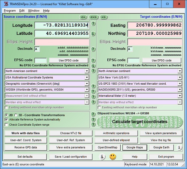
TRANSDAT geosoftware executes coordinate transformations and geodetic datum shifts between many coordinate and reference systems of America, Australasia, Europe, Germany special and world-wide, with high precision and high speed: 1.The current and historical coordinate and reference systems of all countries of the European Union (EU) including the eastern extensions and the systems of non-EU countries. 2. The INSPIRE supported European ETRS89...
Read more
- Rate:

- Release Date:06/06/2017
- License:Shareware
- Category:Microsoft Office
- Developer:Killet Software Ing.-GbR
- Downloads:433
- Size:4.42 Mb
- Price: $170.00
To free download a trial version of TRANSDAT, click here
To buy software TRANSDAT, click here
To visit developer homepage of TRANSDAT, click here
Advertisement
Versions History
| Version | Date Released | Release Notes |
| 20.37 | 06.06.2017 | Choose of file format converting GPS files. New file formats KML and GPX. New NTv2 systems for German Federal States Baden-Wuerttemberg and Bavaria. Automatic search for matching NTv2 files in a common directory. New Reference System GDA2020 and ITRS-Epochs of Australia. |
| 20.21 | 28.03.2017 | All Coordinate- and Reference Systems of Taiwan. New NTv2 systems for German Federal States Baden-Württemberg and Bavaria. Automatic search for matching NTv2 files in a common directory. New Reference System GDA2020 and ITRS-Epochs of Australia. New Serial Interface Monitor displays GPS dataflow. |
| 20.08 | 16.01.2017 | New NTv2 systems for German Federal States Berlin, Bavaria and Mecklenburg. New CRS for Czechia, Slovakia, Albania, Cyprus and Switzerland. Digital signature for secure installation of the program. New internal Text Viewer and dBase Browser. New Serial Interface Monitor diplays GPS dataflow. |
| 19.43 | 02.08.2016 | Serial Interface Monitor for COM ports. Extended support of serial interfaces for GPS receiving. New S-JTSK systems for Czech and Slovakia. All CRS of South- and North-Korea and Mauritius added. TRANSDAT wins 2016 second time Innovation Award. Support of Polygonal Validity Scopes in NTv2 grid files. |
| 19.36 | 01.07.2016 | Extended support of serial interfaces for GPS receiving. New S-JTSK systems for Czechia and Slovakia. All CRS of South- and North-Korea and Mauritius added. Forward and Backward Transformations. TRANSDAT wins 2016 second time Innovation Award. Support of Polygonal Validity Scopes in NTv2 grid files. |
| 19.31 | 18.05.2016 | All CRS of South- and North-Korea added. Implemention of Forward and Backward Transformations. TRANSDAT wins 2016 second time Innovation Award. Support of Polygonal Validity Scopes in NTv2 grid files. WINDOWS©10 certification. ITRS epochs of the EUREF GPS Campaign ITRF2008. |
| 19.11 | 25.01.2016 | Support of Polygonal Validity Scopes in NTv2 grid files. 93 new Minnesota County coordinate systems. WINDOWS©10 certification after intensive test. ITRS epochs of the EUREF GPS Campaign ITRF2008. Display of original designation of chosen EPSG CRS. TRANSDAT wins Innovation Award. |
| 18.15 | 27.09.2015 | WINDOWS©10 certification. ITRS epochs of the EUREF GPS Campaign ITRF2008. French Lambert CC42 upto CC50 coordinates. Display of original designation of chosen EPSG CRS. TRANSDAT wins Innovation Award of Initiative Small and Medium Enterprises. Implementation of the EPSG codes completed. |
| 18.12 | 24.07.2015 | Display of original designation of chosen EPSG CRS. TRANSDAT wins Innovation Award of Initiative Small and Medium Enterprises. All HARN/HPGN gridfile Reference Systems of the United States. Implementation of the EPSG codes completed. New Reference Systems for Italy, Ukraine, Netherlands and Mexico. |
| 17.82 | 10.10.2014 | World-wide direct use of EPSG codes. List with the supported EPSG codes. All HARN/HPGN grid file Reference Systems of the United States. Direct use of Measurement Units. All NTv2 Reference Systems of the German Federal States. Display of coordinates in Google Maps / Earth and OpenStreetMap. |
| 15.10 | 10.02.2012 | Stores user data in separate directory. Supports encrypted NTv2 files. New NTv2 grids of Austria, Spain, Portugal, Germany and Switzerland. New Systems for Denmark, Sweden and Australia. Display of coordinates in GoogleMaps and GoogleEarth. Output of windows contents in GIF/BMP files. |
| 14.30 | 14.09.2011 | Output of windows contents in GIF/BMP files. New CRS Lagestatus 100 DHDN Hessen since Dec. 2007. Supports CSV file format. New projection: Mercator (1SP). New coordinate system: Google Spherical Mercator. New language interfaces Greek, French, Portuguese. Supports INSPIRE, NTv2, Beta2007. |
| 14.12 | 04.05.2011 | New user defineable projection: Mercator (1SP). New coordinate system: Google Spherical Mercator. New language interfaces Greek, French, Portuguese. Reference systems for GPS measurements in ITRS epochs. Accuracy test: 0.04 mm difference. Supports INSPIRE, NTv2, Beta2007. |
Screen Shot
Click on a thumbnail for the larger image.
System Requirements
TRANSDAT requires Win2000, WinXP, Win7 x32, Win7 x64, Windows 8, Windows 10, WinServer, WinOther, Windows2000, Windows2003, Windows Server 2012, Windows Tablet PC Edition 2005, Windows Media Center Edition 2005, WinVista, Windows Vista Starter, Windows Vista Home Basic, Windows Vista Home Premium, Windows Vista Business, Windows Vista Enterprise, Windows Vista Ultimate, WinVista x64, Windows Vista Home Basic x64, Windows Vista Home Premium x64, Windows Vista Business x64, Windows Vista Enterprise x64, Windows Vista Ultimate x64.
TRANSDAT v.20.37 Copyright
Shareware Junction periodically updates pricing and software information of TRANSDAT v.20.37 full version from the publisher using pad file and submit from users. Software piracy is theft, Using crack, password, serial numbers, registration codes, key generators, cd key, hacks is illegal and prevent future development of TRANSDAT v.20.37 Edition. Download links are directly from our publisher sites. Links TRANSDAT v.20.37 from Bittorrent, mediafire.com, uploadfiles.com, hotfiles.com rapidshare.com, megaupload.com, netload.in, storage.to, depositfiles.com and other files hosting are not allowed. The download file is obtained directly from the publisher, not from any Peer to Peer file sharing applications such as Shareaza, Limewire, Kazaa, Imesh, eDonkey, eMule, Ares, BearShare, Overnet, Morpheus, BitTorrent Azureus and WinMX.
Review This Software
More TRANSDAT Software
Advertisement

TRANSDAT English v.17.75
TRANSDAT Coordinate Conversion supports thousands of coordinate systems and geodetic datum shifts, user-defined systems, INSPIRE, NTv2, BeTA2007, GPS, continental drift, Shape, KML, CSV and other file systems and much more with highest accuracy.

TRANSDAT Deutsch v.17.75
TRANSDAT Coordinate Conversion supports thousands of coordinate systems and geodetic datum shifts, user-defined systems, INSPIRE, NTv2, BeTA2007, GPS, continental drift, Shape, KML, CSV and other file systems and much more with highest accuracy.
TRANSDAT (English)
TRANSDAT Geosoftware executes coordinate transformations and geodetic datum shifts between lots of coordinate and reference systems of Germany, Europe, America, Australia and world wide. The current and historical coordinate and reference systems
TRANSDAT v.20.37
TRANSDAT Coordinate Conversion supports thousands of coordinate systems and geodetic datum shifts, user-defined systems, INSPIRE, NTv2, BeTA2007, GPS, continental drift, Shape, KML, CSV and other file systems and much more with highest accuracy.

TRANSDAT (Deutsch) v.12 5
TRANSDAT Geosoftware executes coordinate transformations and geodetic datum shifts between lots of coordinate and reference systems of Germany, Europe, America, Australia and world wide in high quality and with high performance: 1.
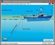
DRAGSENS v.4.01
DRAGSENS Geo Software is used for the exact position estimation of a towed body, sensor, camera, array or net, dragged behind a ship, aircraft or vehicle. The software allows a real-time estimation of the position of a dragged sensor.

SEVENPAR v.8.01
SEVENPAR calculaties exact parameter sets for the Spatial Helmert or Molodensky Transformation with seven or three parameters, which are used for accurate geodetic datum shifts between different reference systems for coordinate transformations.

SEVENPAR English v.3.14
SEVENPAR calculaties exact parameter sets for the Spatial Helmert or Molodensky Transformation with seven or three parameters, which are used for accurate geodetic datum shifts between different reference systems for coordinate transformations.

SEVENPAR Deutsch v.4.16
SEVENPAR calculaties exact parameter sets for the Spatial Helmert or Molodensky Transformation with seven or three parameters, which are used for accurate geodetic datum shifts between different reference systems for coordinate transformations.
Other products of this developer Killet Software Ing.-GbR

DRAGSENS v.4.01
DRAGSENS Geo Software is used for the exact posi... estimation of the position of a dragged sensor.

Geodata Germany v.22.03
The database contain geodata of the Federal Repu...capes, climatic zones for proximity searches ec.

Geodata International v.10.05
Geodata International - World-wide database of c...ximity search, navigation, distance calculation.

GeoDLL v.18.24
GeoDLL is a Geodetic Development Kit / Geodetic ...rt, NTv2, HARN, INSPIRE, EPSG, DEM and much more

Graphics4VO DLL v.11.04
Graphics4VO is the graphics interface for the pr... the display, printer, plotter, file and memory.

ORTWIN v.13.02
ORTWIN is a program for the inquiry of localitie...capes, natural units, snow- and wind load zones.

SEVENPAR v.8.01
SEVENPAR calculaties exact parameter sets for th...eference systems for coordinate transformations.

TOPOWIN v.16.00
TOPOWIN is a state-wide register of the German t...ms. It also is a topographic information system.